
Australia: The Land Where Time Began
Tumblagooda Sandstone Formation See also
The redbed of the Tumblagooda Sandstone was deposited during the Ordovician in a braided fluvial and tidal sandflat, the Gascoyne Platform being covered by coastal redbed settings, extending at least 700 km to the south of Kalbarri, and as far as Onslow to the north of Kalbarri. It extended to 10 km east of Bringo in the northern Perth Basin. The Ordovician basin was an interior fracture basin that opened to the north, that developed in equatorial to latitudes that were low tropical. The location of the western margin of this basin is unknown (Source 2).
In the Murchison River gorge, and adjoining coastal gorges, in the Kalbarri National park are the best outcrops of the Tumblagooda Sandstone. In a section dipping at an angle that rarely exceeds 5o, there is an exposure of fluvial to tidal redbed facies that reach about 1300 m. It is the only exposure of formations from the lower Palaeozoic that occur in the Southern Carnarvon Basin. The Tumblagooda Sandstone underlies dolomite, limestone and evaporites from the Silurian, in the subsurface, of shallow marine origin. Low dips characterise these units, that extend across the basin, with the exception of the easternmost part (Hocking et al., 1987; Iasky et al., 2003). (Source 2). Trace fossils are the only indication of the age of the Tumblagooda Sandstone (Trewin & McNamara, 1995), though they are not very age diagnostic, but an minimum age is indicated by the presence of paddle mark tracks, in the middle of the unit, that are believed to have been made by Eurypterids that first appear in the fossil record in the Arenig (Early-Middle Ordovician) according to McNamara in Mory et al., 2003. The age range had previously been suggested to be Middle Cambrian to Cretaceous (Iasky & Mory, 1999, Table 1), based on palaeomagnetic data the Early Ordovician age is the most constrained (Schmidt & Hamilton, 1990) (Source 2).
A high flux of sediment, that is believed to have resulted from periodic faulting along the margin of the basin, that is implied by the predominantly sandy facies of the Tumblagooda Sandstone. Near the end of the Ordovician, the flow of terrigenous sediment to the basin slowed, as a long period of tectonic quiescence began, allowing the accumulation of deposits that were predominantly dolomitic in settings of nearshore marine to marine shelf (Dirk Hartog Group, that occurs only in the subsurface to the north of Kalbarri). The environments were from relatively high energy to low and the salinities are thought to have ranged from probably normal to hypersaline (Source 2).
The facies associations of the type section, about 1300 m thick, of the Tumblagooda Sandstone in the gorge of the Murchison River has been divided into 4 sections (Hocking, 1991). Outcropping in the stratigraphic sequence up to the type section, they delineate 2 sharp-based megacycles dominated by fluvial facies, that are fining upward. Deposits overlying them, originating as tidal sandflat or interdistributory bay sediments (FA1 to FA2, and FA3 to FA4). It appears there was very little scatter from the northwest flowing palaeochannels (Mory et al., 2005). The Z Bend section mainly derives from sandflat sedimentation (FA2), and near the base a fluvial sheet persists laterally towards the top of the lower couplet. From the top of the upper fluvial sandstone interval (FA3), up into the distributary bay and deposits of coastal channel origin (FA4), are the coastal cliff sections (Source 2).
See Source 2
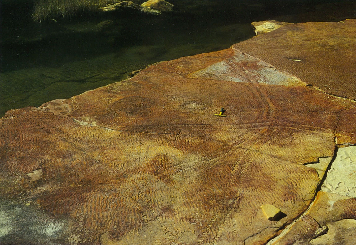
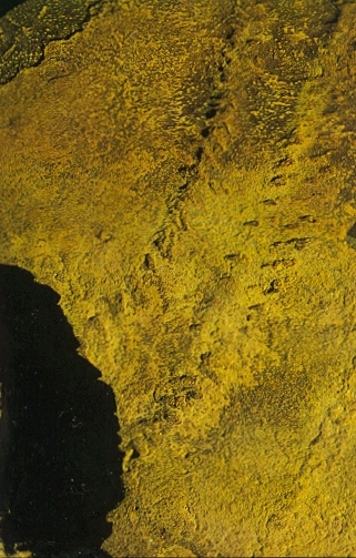
What is probably the first known footprints on land are found here. Eurypterids were one of the first animals to venture out onto the land. On a rock platform are the tracks made in the Late Silurian by Eurypterids.
In various places in this formation there are many worm tubes and burrows that stand out from the cliff faces because the surrounding rocks have been eroded away.
Tracks left by large Eurypterids
- Penny Van Oosterzee, 1993, The Centre - The Natural history of Australia's Desert Regions, Reed Australia.
- Geology of the Northern Perth Basin, Western Australia - a field guide
Links
| Author: M. H. Monroe |
| Email: admin@austhrutime.com |
| Last Updated : 04/01/2015 |
| Kalbarri Coast |
| Kalbarri National Park |
| Home |
| Journey Back Through Time |
| Geology |
| Biology |
| Fauna |
| Flora |
| Climate |
| Hydrology |
| Environment |
| Experience Australia |
| Aboriginal Australia |
| National Parks |
| Photo Galleries |
| Site Map |